
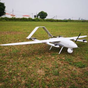
Description
Product Description
| Model features | |
| Vertical take-off and landing | Low requirements for landing and landing points, high operating efficiency. |
| Simple structure | Easy to operate in a short time. |
| Full autonomous flight | One-button take-off, safe and efficient. |
| High security | Double protection for emergency landing and open umbrella. |
| Duration of flight | 120 minutes |
| Aircraft Parameters | |
| Cruise speed | 60-100KM/H |
| Aircraft length | 1.45M |
| Wing width | 2.5M |
| Maximum takeoff weight | 12KG |
| Payload | 1-2KG |
| Wind resistance | Grade 6 |
| Power System | Electric Powered |
| Body material | Full composite material |
| Packing |
128*48*50cm, 15Kg |
Autopilot performance:
full coverage of the model;
Satellite navigation
[real-time GPS/GLONASS/Galileo/B Multi-system signal reception];
attitude accuracy 0.5deg, heading accuracy 1deg;
centimeter-level positioning;
High precision and high dynamic motion measurement.


UAV Ground Control Station

| ITEM | Functions/Technical Parameters |
| FEATURES |
1. UAV control: parameter setting, flight check, route planning, flight data display, flight status monitoring, abnormal alarm, flight data saving and playback; 2. Video image display: real-time display of the pod capture image: 3. Data link: integrated flight control data link, HD Image transmission link; 4. 12V DC power supply: 12V DC power output (maximum power 24W); 5. WiFi function: The computer can connect to the public network via WiFi; 6. USB interface: 3 USB device connection interfaces; 7. Image output: 1 HD HDMI video output interface; 8. Can integrate image transmission and digital transmission links; 9. Other functions can be customized according to customer requirements. |
Surveying Mapping Camera(OPTIONAL)


30x zoom Object Tracking Camera(STANDARD)

1,Function description
Build-in normalization ,cross-correlation and tracking algorithm,
combining with object missing recapture algorithm, achieve stable
track of the target.
Support custom characters of user OSD, adaptive gate, cross
cursor, trace information display.
2,Tracking performance
1)Update rate of deviation pixel 50Hz
2)Output delay of deviation pixel <15ms
3)Minimum target contrast 5%
4)the minimal signal-to-noise ratio ( SNR) 4
5)Minimum target size 16*16 pixel
6)Maximum target size 160*160 pixel
7)Tracking speed 32 pixel/frame
8)The mean square root values of pulse noise in the target
position<0.5 pixel

Reviews
There are no reviews yet.